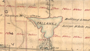
In much of cottage country, private "waterfront" properties may not actually extend to the lake. Often there is a 20 metre (66 foot) strip of land immediately next to the lake that is an Allowance for Road. This is owned by the local Municipality or Township. These Original Shore Road Allowances (OSRA) were created between the 1850s and 1870s when these Townships were first surveyed under Instructions from the provincial government. In some cases where lakes were dammed after the original Township Surveys, these OSRAs may now be partially or totally submerged.
Most Municipalities are agreeable to selling these Allowances for Road to the upland private property owners, but can only sell the dry land portions. Prior to selling, the Public interest in these Allowances (after all, they are "Roads"!) must be removed by a process called Closing.

Parallel red and black line bordering Tallans Lake marks 20.12 m SRA
on original Crown Plan - Chandos Township, municipal Township of North Kawartha,
Peterborough County
The growth in "Cottage Country" accelerated in the post war years. The Department of Lands and Forests (now the Ministry of Natural Resources and Forests or MNRF) was responsible for creating many new lots, often with Allowances for Road adjacent to the waterfront. In the case of a flooded lake, this had the effect of creating a second, possibly overlapping, Road Allowance. At the time, common belief (and enforced by provincial policy) was that OSRA along dammed lakes "moved" with the flooded limit. This is now realized to not be true. And just to confuse this more, sometimes the Crown Survey Plan creating the property would refer to the 66 foot strip as "Reserve". Or sometimes would not label it at all.
Current policy (based on the Municipal Act) is that if the Crown Survey Plan calls the lakefront strip "Road", then it is an Allowance for Road, owned by the Municipality. If not depicted as a Road, then the strip is retained Crown Lands, and an application must be made to the MNRF to acquire it.
Our firm has thousands of records of surveys along lakes in cottage country. We have researched many controlled lakes and have established original lake elevations for many of these flooded lakes.
